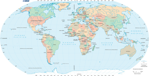
The map- mundi or world map is a cartographic representation showing the globe in a comprehensive manner.
It brings together the emerged parts like the continents, islands, countries, states and cities (usually the capitals) and the great masses of salt water: the oceans and seas of the world.
Remember that the planet Earth is a sphere and the poles (north and south) are slightly flattened.
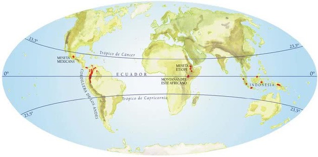
Imaginary Lines :
The world map features some imaginary islands that make it easy to find the geographical coordinates of the terrestrial globe. The main imaginary lines are:
World map
- Equator : which divides the world horizontally into two hemispheres: north (northern) and south (southern).
- Tropic of Cancer : cuts the globe horizontally and is located above the Equator, in the northern hemisphere.
- Tropic of Capricorn : cuts the globe horizontally and is located below the equator in the southern hemisphere.
- Arctic Circle : located in the extreme north of the world (north pole), the countries that are above this line have a subarctic climate.
- Antarctic Polar Circle : imaginary line that passes through the extreme south of the world (south pole) on the continent of Antarctica. There are no inhabitants there.
Continents of the World
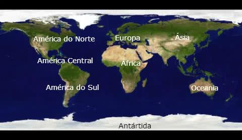
World map
The world is made up of 6 continents , namely:
- Asia
- America (divided into: North America , Central America and South America )
- Africa
- Antarctica
- Europe
- Oceania
Oceans of the World:
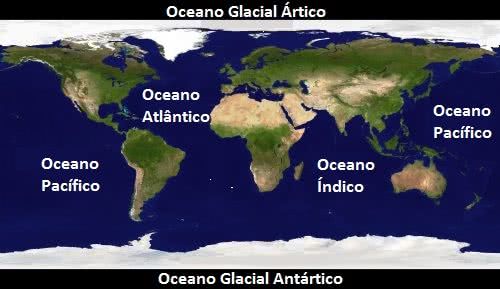
Five oceans are part of the world map, namely:
- Pacific Ocean
- Atlantic Ocean
- Indian Ocean
- Arctic Glacial Ocean
- Antarctic Glacial Ocean
Countries of the world
According to the UN (United Nations), the world is made up of 193 countries. Thus, it does not recognize Taiwan, the Vatican and Palestine that are in the category of “observer states”.
In such a way, to be considered a country it has to unite characteristics such as national sovereignty, well-defined borders and even a currency.
However, there are world entities that present other figures in relation to the number of countries that exist in the world. The International Olympic Committee establishes 206 countries, and FIFA, 209.
Check out the countries of each continent below:
- Asia has 47 countries and 3 national sovereignty territories
- America has 35 countries and 20 national sovereignty territories
- Africa has 54 countries and 4 territories of national sovereignty
- Europe has 43 countries and 10 national sovereignty territories
- Oceania has 14 countries and 11 national sovereignty territories
Note : Despite being considered a continent, Antarctica does not contain any country.
Find out more :
- Asian countries
- North American countries
- Central American countries
- South American countries
- African countries
- European countries
- Oceania Countries
Representations of the World Map
There are several ways to represent the world map (and still others) called cartographic projections .
The map of the world was not always represented in the way we know it today. The first known world map dates from VII BC, made of clay and found in the region of Babylon.
Certainly the discoveries were evolving and from the sixteenth century onwards it was approaching the way we know it. See below the main known cartographic projections:
- Mercator projection
- Peters Projection
- Robinson Projection
- Mollweide Projection
- Behrmann projection
- Albers Projection
- Polar Equidistant Azimuthal Projection
- Hölzel projection
- Van Der Grinten projection
- Goode’s Discontinuous Projection
- Sinusoidal Projection