Brazil has a huge territorial area and has a hydrographic network formed by extensive rivers and large volumes of water. In the world, the country has the largest hydrographic basins on the planet.
Brazilian Hydrographic Regions
Brazil has 12 hydrographic regions formed by several hydrographic basins , from where the main rivers of the country are located: Amazonas, São Francisco, Tocantins, Araguaia, Parnaíba, Paraguay, Paraná, Uruguay, among others. See below the main hydrographic basins in the country:
Amazon Basin
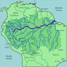
The Amazon Basin is the largest hydrographic basin in the world. It is formed by the Amazon River and its tributaries, extends over an area of 7,008,307 km², of that total, 3,843,402 km² are in Brazil. It also occupies lands in Peru, Venezuela, Colombia, Ecuador, Bolivia and Guyana.
Its main river, the Amazonas, rises in the Mclntyre Lagoon, in the Nevado Mismi, in the Andes Mountains, in Peru, at 5,600 meters above sea level, according to scientific research carried out by the National Institute for Space Research (INPE).
Then, its waters flow through the Apurimac River and other tributaries until it is called Solimões, on the Brazilian border, until it meets the Negro River.
From there it receives the name Amazonas, forming the largest hydrographic basin in the world. After crossing the vast Amazon Plain from west to east, the Amazon River empties into the Atlantic Ocean. It is considered the second longest river in the world and the one with the highest volume of water.
The tributary network of Amazonas consists of extensive rivers, such as Purus, Madeira, Tapajós, Xingu, Negro, Juruá, Jari and many others.
As most of the Amazon region has a very humid climate with rain in almost every month of the year, most of its rivers have an equatorial regime, where a long period of floods and a short drought predominate, which facilitates the navigation.
In an immense region like the Amazon , rivers play an important role in regional human occupation. The inhabitants are dispersed along the rivers, which constitute an important source of food, and in much of the region, the only circulation routes.
Tocantins Basin – Araguaia
The Tocantins-Araguaia Basin is the largest hydrographic basin in Brazil. It offers much of its navigable course. It is the second in energy production in Brazil, and is located in the Eastern Amazon.
It extends for 918,822 km², from the confluence of the Maranhão river with the Rio das Almas in Goiás, until the mouth in the bay of Marajó, in the state of Pará.
Its main rivers are Tocantins and Araguaia, which extend through the states of Tocantins, Goiás, Mato Grosso, Pará, Maranhão, in addition to the Federal District. On its course is the island of Bananal, in the state of Tocantins, the largest river island in the world.
The Tucuruí Hydroelectric Plant, built on the Tocantins River, in the municipality of Tucuruí, in the state of Pará, is the largest hydroelectric plant in Brazil. It is responsible for supplying energy to most of the states of Pará, Maranhão and Tocantins. A 5.5 km lock and channel allow navigation over much of the river.
São Francisco Basin
The São Francisco River Basin , formed by the São Francisco River and 158 tributaries, extends over an area of 640,000 km², occupying 8% of the national territory, covering the states of Minas Gerais, Bahia, Pernambuco, Alagoas, Sergipe , Goiás and the District Federal, bathing 521 municipalities.
The São Francisco River is the main course of the Basin, with an extension of 2,700 km. It is born in the Serra da Canastra, in Minas Gerais, and after traveling through the states of Minas Gerais, Bahia, Pernambuco, Alagoas and Sergipe, it flows into the Atlantic Ocean, on the border between Alagoas and Sergipe.
The São Francisco River has many waterfalls, which are used to generate electricity. Among the plants in this basin, Paulo Afonso, Sobradinho, Xingó and Luiz Gonzaga, supply energy that supplies the Northeast Region, and Três Marias that supplies part of the Southeast Region.
The São Francisco River, with more than 2,000 km of navigable stretches, is the only perennial river (never dry) that crosses the semi-arid northeastern hinterland, the driest region in Brazil. Its waters are used for irrigation of plantations. The other rivers are intermittent (they dry out for part of the year).
Platinum Bowl
The Platinum Basin is formed by the Paraná, Paraguay and Uruguay rivers and their tributaries. In the Brazilian territory they form separate river basins ( Paraná Basin , Paraguay Basin and Uruguay Basin ), but they join in the Prata estuary, between Uruguay and Argentina.
The Paraná River has 2,400 navigable km and brings Brazil closer to its Mercosur partners. Among the tributaries of the Paraná River, the Paranapanema River, Peixe, Grande and Tietê stand out.
The Paraná Basin has the largest hydroelectric potential installed in the country, including the Itaipu Binational Plant, built in partnership between Brazil and Paraguay. With the construction of locks next to the plants, the basin has important sections for navigation, with emphasis on the Tietê waterway.
The Paraguay River is a typical lowland river, crossing the Pantanal Mato-Grossense and is used as a waterway to drain the manganese ore from the Massif do Urucum. Its largest river port is Corumbá, in Mato Grosso do Sul. The Paraguay River also bathes the countries of Paraguay, Bolivia and Argentina.
The Uruguay River rises from the junction of the Canoas and Pelotas rivers, runs through typical stretches of plateau and stretches of plain between São Borja and Uruguaiana, in Rio Grande do Sul, where it is used for navigation. In its course, the Garibaldi plants on the Canoas river and Machadinho plants on the Uruguay river stand out.