The Map of Brazil shows the geographic representation of the country, bringing together the capitals, states and cities that comprise it.
The current political map of Brazil contains 26 states and the Federal District . It has been in force since 1988, when the State of Tocantins was created, from the division of the territory of Goiás.
With the Constitution of 88, the territories of Rondônia, Roraima and Amapá became States and the Fernando de Noronha archipelago was annexed to Pernambuco.
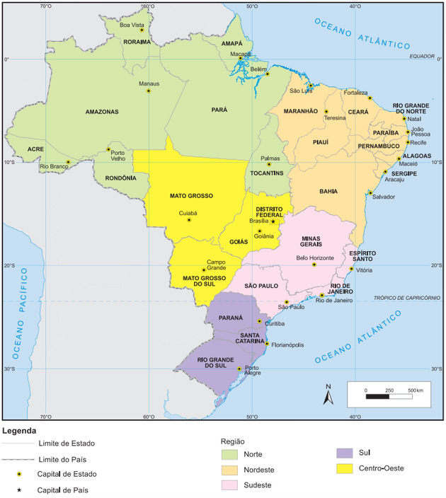
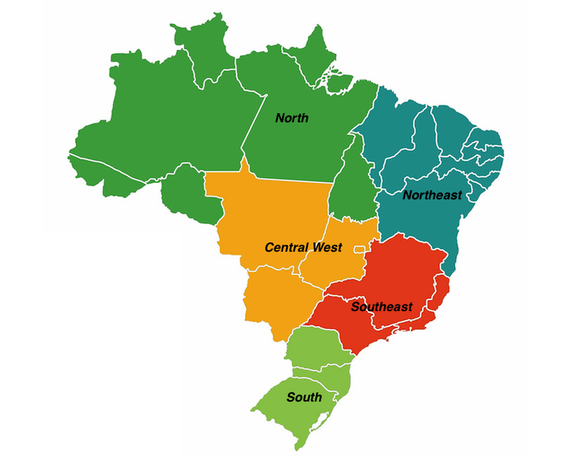
Maps of the Regions of Brazil
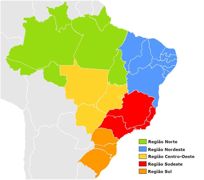
North region
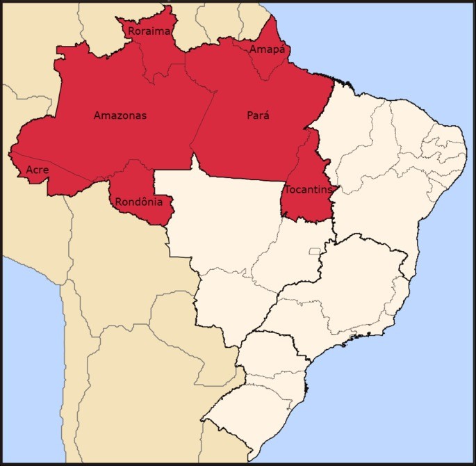
With an area of 3,853,676,948 km², equivalent to 42.27% of the national territory, the northern region is the largest in the country.
It is formed by 7 states: Acre, Amapá, Amazonas, Pará, Rondônia, Roraima and Tocantins.
Northeast Region
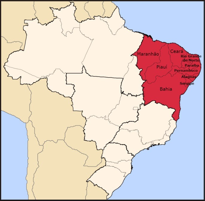
With an area of 1,554,291.607 km², equivalent to 18.27% of the national territory, the northeast region is formed by 9 states: Alagoas, Bahia, Ceará, Maranhão, Paraíba, Pernambuco, Piauí, Rio Grande do Norte and Sergipe.
Southeast region
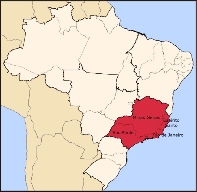
With an area of 925 511 km², equivalent to 10.85% of the national territory, the southeast region is the most populous in the country.
It is formed by 4 states: Espírito Santo, Minas Gerais, Rio de Janeiro and São Paulo.
South region
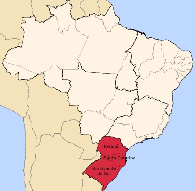
With an area of 576,774.310 km², which corresponds to 6.76% of the Brazilian territory, the southern region is the smallest in the country.
Three states are formed: Paraná, Santa Catarina and Rio Grande do Sul.
Midwest region
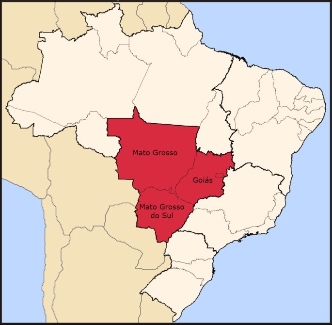
With an area of 1,606 399,509 km², equivalent to 18.86% of the national territory, the central-west region is the second largest in the country.
It is formed by 3 states: Goiás, Mato Grosso and Mato Grosso do Sul.
See also : Brazilian regions
Thematic Maps of Brazil
A map of Brazil can be represented by different geographical, historical, political and demographic aspects. Thus, maps that represent a specific subject are called thematic maps. For example:
- The climate and its meteorological phenomena – climate map
- Vegetation cover – vegetation map
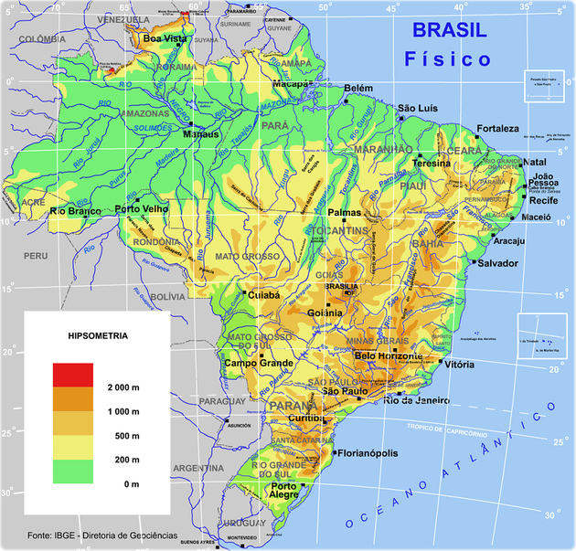
- The reliefs and altitudes – physical map
- Transport – (highways, railways, navigable rivers) – transport map
See the example of the Physical Map of Brazil showing its relief and altitudes:
History of the Map of Brazil
The limits of the future Brazilian territory were defined even before the discovery, in 1494, with the signing of the Treaty of Tordesillas, between Portugal and Spain.
Treaty of Tordesillas
Under the Treaty of Tordesillas, the Lusitanian domain consisted of all the land on the eastern side of an imaginary line drawn west of Cape Verde. On the other hand, the western part belonged to Spain.
The representation of the map of Brazil according to the definitions of the agreement was indicated by the Portuguese cartographer Luís Teixeira in 1574.
First Maps
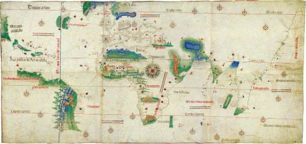
The first graphic representation of Portuguese America appears on the map of Juan de la Cosa (1460-1510), navigator, cartographer and Spanish diplomat.
He had accompanied Christopher Columbus on his first and second expedition, in 1492 and 1493, respectively.
He would return to America in the squadron led by Alonso de Ojeda (1466-1516) and when he returned he made a map, probably at the request of Kings Isabel and Fernando.
The map is one of the most updated of its time and already includes the land sighted by Vasco da Gama and Bartolomeu Dias. It also brings Central and South America.
The Portuguese lands appear in blue with the indication “island discovered by Portugal”, which shows that Juan de la Cosa was familiar with the arrival of Pedro Álvares Cabral to that place .
This map is on permanent display at the Naval Museum in Madrid:
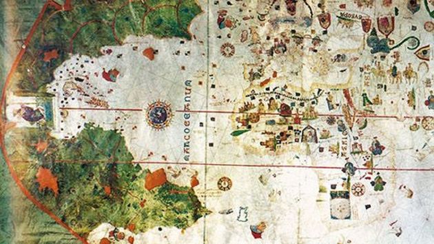
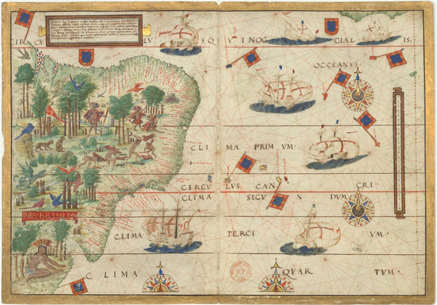
The first graphic representations about Brazil date from 1502 and were organized by the Italian merchant Alberto Cantino.
Cantino was a spy in the service of the Duke of Ferrara and bought the document while in Lisbon. The map probably dates from 1502 and its description of the Portuguese American coast already shows details of the coast.
The author of the map is not known, but he knew the results of the expedition integrated by the Italian navigator Américo Vespúcio (1454-1512).
The original of this map can be found at the Modena Library, in Italy.
An Italian, Jerônimo Marini, was also the first cartographer to make a map with the denomination of Brazil, in 1511.
Portuguese Atlas
The Portuguese Atlas also known as Atlas Muller was made at the request of King Dom Manuel (1569-1521).
In addition to accurately representing the future coast of Brazil, it is illustrated with the riches that the New World possessed: wood, rivers, exuberant nature, naked natives, imaginary and real animals.
Portuguese America was called Terra Brasilis. The original document is currently in the Library of Paris.
Since the Portuguese settled on the land and colonized it, the maps have been improving.
However, it was the Dutch who started to study the mapping of the region more after 1630. This occurred as a result of the installation of the West India Company in the Northeast region.
Cartography was used as a basis to guarantee Portuguese domination on several occasions in history. Due to the risk of losing the territory, the Portuguese Crown was forced to invest in cartographic studies.
Atlas of Brazil
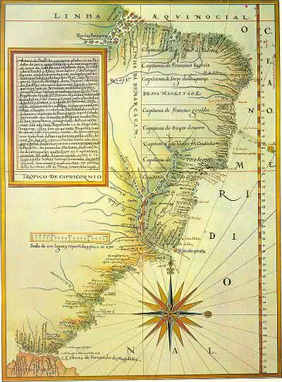
The first Atlas of Brazil was made by the cartographer João Teixeira Albernaz the Elder , in 1640. The cartographic maps show that the domination of Brazil started at the Rio da Prata, included Uruguay, and ended at the mouth of the Amazon River.
The publication featured the map of several provinces in Lusitanian America such as Rio Grande do Sul and Uruguay (claimed by the Portuguese crown).
The search for knowledge of the territory and its representation on paper remained intense after the signing of the Utrecht Treaty in 1713.
It was, however, in 1729, that the work received priority order. Nine years earlier, a French study questioned the border with French Guiana and the Portuguese Crown sent a Jesuit mission to detail the national domains.
The studies were completed by the Portuguese diplomat Alexandre Gusmão (1695-1753), who prepared the Map of the Courts . The results were used to support the negotiations of the Treaty of Madrid in 1750, which defined the areas of Portuguese and Spanish ownership.
More details about the borders and the internal division of the Portuguese colony were left to astronomers, military engineers, draftsmen and mathematicians.
The studies resulted in a Geographic Map of Espherica Projection from Nova Lusitânia or América Portuguesa and Estado do Brasil, published in 1797.