
The Brazilian relief is characterized by low and medium altitudes. The predominant forms of relief are plateaus and depressions (formations of crystalline and sedimentary origin).
Both occupy about 95% of the territory, while the plains, of sedimentary origin, occupy approximately 5%.
Thus, about 60% of the territory is formed by sedimentary basins, while about 40% by crystalline shields.
Story
First, remember that the relief constitutes the shapes of the Earth’s surface, formed by the movement of tectonic plates, volcanism. They are structures resulting from internal and external factors to the earth’s crust.
In the early 90s, Brazilian geographer and professor Jurandyr Ross, proposed the newest systematization of Brazilian relief.
According to him, the country has 28 relief units , classified according to its three main forms: plateau , plain and depression .
However, the first classification of the Brazilian relief was proposed by the Brazilian geographer Aroldo Azevedo (1910-1974), in 1949, based on the altimetry of the territory. It was divided into plains and plateaus, formed by 8 units of relief.
Consequently, in the late 1950s, Aziz Nacib Ab’Saber (1924-2012) focused on the processes of erosion and sedimentation that classify the plains and plateaus of Brazil.
Relief Classification
The three predominant landforms in Brazil are:
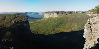
Highland
Also called plateaus, the plateaus are elevated and flat terrains marked by altitude above 300 meters and erosive wear predominate.
In this regard, they are classified according to geological formation:
- Sedimentary Plateau (formed by sedimentary rocks)
- Crystalline Plateau (formed by crystalline rocks)
- Basalt Plateau (formed by volcanic rocks)
Flat land
Flat terrain with altitudes that do not exceed 100 meters, in which the sediment accumulation process predominates. Thus, they can be:
- Coastal Plain (constituted by the action of the sea)
- Fluvial Plain (constituted by the action of a river)
- Lacustrine Plain (constituted by the action of a lake)
Depressions
Formed by the erosion process, the depressions are relatively steep terrain and have altitudes below the surrounding areas (from 100 to 500 meters).
They are classified into:
- Absolute depressions (located below sea level)
- Relative depressions (found above sea level)
Also read :
Plateaus of Brazil
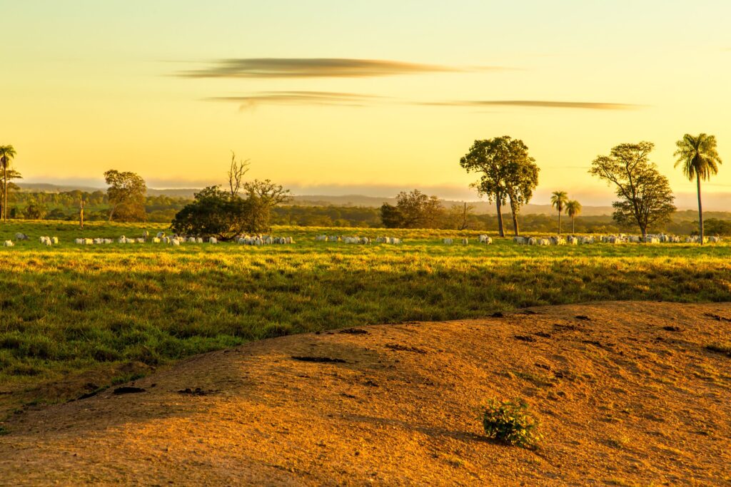
In the Brazilian territory there is a predominance of plateaus. This type of relief occupies about 5,000.00 km 2 of the total area of the country, of which the most common forms are the peaks, mountains, hills, hills and plateaus.
In general, the Brazilian plateau is divided into southern highlands , central highlands and Atlantic plateau :
Central Plateau
The central plateau is located in the states of Minas Gerais, Tocantins, Goiás, Mato Grosso and Mato Grosso do Sul.
The site has great electrical potential with the presence of many rivers, where the São Francisco, Araguaia and Tocantins rivers stand out.
In addition, there is a predominance of vegetation in the cerrado. Its highest point is Chapada dos Veadeiros , located in the state of Goiás and with altitudes ranging from 600 m to 1650 m.
Guyana Plateau
Located in the states of Amazonas, Pará, Roraima and Amapá, the Guiana Plateau is one of the oldest geological formations on the planet.
It also extends to neighboring countries: Venezuela, Colombia, Guyana, Suriname and French Guiana.
Mostly formed by tropical vegetation (Amazon Forest) and mountains. It is here that the highest point of the Brazilian relief is found, that is, the Pico da Neblina with about 3,000 meters of altitude, located in the Serra do Imeri, in the State of Amazonas.
Brazilian Plateau
Formed by the Central Plateau, Southern Plateau, Northeastern Plateau, Eastern and Southeastern Mountains and Plateaus, Maranhão-Piauí Plateaus and Uruguaio-Rio-Grandense Plateau.
The highest point of the Brazilian plateau is the Pico da Bandeira with about 2,900 meters, located in the states of Espírito Santo and Minas Gerais, in the Serra do Caparaó.
Southern Plateau
Located, in its great majority, in the south of the country, the southern plateau also extends to the regions of the midwest and southeast in Brazil.
Its highest point is Serra Geral do Paraná, present in the states of Rio Grande do Sul, Paraná and Santa Catarina.
It is divided into: sandstone-basalt plateau, which form the mountain ranges ( cuestas ) and the peripheral depression, characterized by lower elevations.
Northeastern Plateau
Located in the northeast region of the country, this plateau has the presence of plateaus and crystalline mountains, where the Serra da Borborema stands out .
It is located in the States of Alagoas, Pernambuco, Paraíba and Rio Grande do Norte, with a maximum altitude of 1260 m.
The highest peaks in the Serra or Planalto da Borborema are Pico do Papagaio (1260 m) and Pico do Jabre (1200 m).
Eastern and Southeastern Mountains and Plateaus
It is known by the name ” sea of hills “. It involves a large part of the Atlantic plateau, on the coast of the country, the mountains and plateaus of the east and southeast.
They cover the states of Paraná, Santa Catarina, São Paulo, Goiás, Minas Gerais, Rio de Janeiro, Espírito Santo and Bahia.
Highlights include the Serra da Canastra , Serra do Mar and Serra da Mantiqueira .
Plateau of Maranhão-Piauí
Also called the mid-north plateau, this plateau is located in the states of Maranhão, Piauí and Ceará.
Dissected Southeast Plateau (Escudo Sul-rio-grandense)
Located in the state of Rio Grande do Sul, the south-rio-grandense shield has elevations of up to 550 meters, which characterizes the state’s mountain range.
One of the highest points is Cerro do Sandin , with 510 meters of altitude.
Plains of Brazil
The plains of Brazil occupy about 3,000,000 km 2 of the entire territory, the main ones being:
Amazonian Plain
Located in the state of Rondônia, this type of relief characterizes the largest lowland area in Brazil. The most frequent forms are the floodplain region, river terraces (tesos) and low plateau.
Pantanal Plain
Located in the states of Mato Grosso and Mato Grosso do Sul, the wetland plain is a land prone to flooding. Therefore, it is marked by several marshy regions.
Remember that the Pantanal is the largest floodplain in the world.
Coastal Plain
Also called the coastal plain, the coastal plain is a strip of land located in the coastal region of the Brazilian coast, which has approximately 600 km.