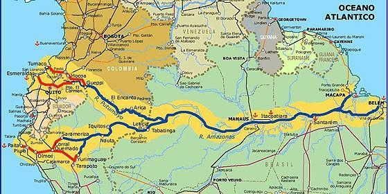
The Amazon River , located in South America, is the largest river in the world in terms of water volume and the largest river in the world in extension , with 6,992.06 km.
The Amazon River originates at the source of the Apurimac River , on the slope of Nevado Mismi , in the Andes Mountains, in Peru , at 5,600 meters above sea level.
Summary of the Amazon River
The Amazon River receives several names and several tributaries in its course in Peru, until receiving the name of Solimões , on the border of Brazil, in the municipality of Tabatinga, in the state of Amazonas , where it continues its course until it finds the Negro River , close to the city Manaus, where it is called the Amazon River .
Thus, the Amazon River crosses the states of Amazonas and Pará until it reaches its mouth, 300 km wide in the great Delta of Amazonas, between the states of Amapá and Pará .
Amazon river
When entering the Brazilian territory, in the municipality of Tabatinga (AM), the Amazon River is just 60 m high and travels almost 3,000 km in a lowland region, to flow into the Atlantic.
Along this stretch it has an insignificant drop of 20 mm per kilometer. The slight unevenness provides excellent navigability conditions, from its mouth to the city of Manaus.
Amazon River tributaries
The Amazon River has approximately 1,100 tributaries that form the largest hydrographic basin in the world, with an extension of 7,008,370 km².
The Amazon River flows through the territories of Peru, Brazil, Colombia, Bolivia, Ecuador, Guyana and Venezuela. In Brazil the river stretches for 3,843,402 km² and bathes the states of Acre, Amazonas, Amapá, Rondônia, Roraima, Pará and Mato Grosso.
The Amazon River has tributaries on both sides of its banks , and because they are located in the two hemispheres (north and south), they allow the double capture of water from summer floods.
Main tributaries of the Amazon River on the right bank: Javari, Purus, Madeira, Tapajós, Xingu etc.
Main tributaries of the Amazon River on the left bank: Iça, Japurá, Negro, Trumpets, Jari etc.
Floods and droughts of the Amazon River
Every year, with the melting in the Andes and the rainy season in the Amazon region, there is the phenomenon of floods that affect the municipalities that are on the banks of the Solimões, Amazonas, Tapajós, Negro, Juruá, Purus, Japurá, Madeira rivers, among others.
With the 2011 flood, the Tapajós River reached 7.48 meters and was considered the biggest flood in recent times. During the dry season, the drought phenomenon also affected the region; in 2010 the greatest drought in the last 100 years occurred.
Pororoca
Pororoca is the phenomenon characterized by the encounter of a large river with the sea, and this shock causes a huge noise and generates large and violent waves causing strong destruction in its course, thus modifying the banks of the rivers and destroying the riverside vegetation.
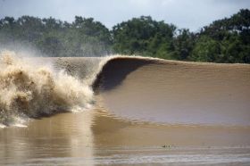
On the Amazon River, the pororoca occurs at the mouth, in the encounter with the Atlantic Ocean, normally in the months of October. During the phenomenon, the waves approach three meters in height, reaching a speed of 50 km per hour.
Curiosities about the Amazon River
- The Amazon River runs through one of the largest tropical forests in the world, the Amazon Forest. The flora of the Amazon has a wide variety of species, being the greatest biodiversity on the planet, including more than 1.5 million plant species cataloged.
- The Negro River is the second largest river in the world in terms of water volume and the largest tributary of the left bank of the Amazon River. Its dark waters meet the muddy waters of the Solimões River near the city of Manaus, where they run side by side, without mixing over 6 km.