The Easter Island is one of the places in the world whose natural beauties and traditions make it particularly attractive. It is located in the middle of the Pacific Ocean , in front of the Port of Caldera, forming part of the island territory of Chile .
From a political point of view, the island is made up of the commune of Isla de Pascua, which is the only commune that belongs to the province of Isla de Pascua, in the Valparaíso region ( Republic of Chile .
The commune and the province groups Easter Island and Salas y Gómez Island .
The capital of the commune and the province is the town of Hanga Roa , located in the southeastern area of the main island, where the entire population is concentrated.
Today, due to its enormous archaeological wealth and undeniable natural beauties, Easter Island is considered the most interesting open-air museum in the world, whose greatest wealth is the nearly a thousand gigantic volcanic stone statues (Moai), its attractive beaches with transparent waters and its ancient petroglyphs that testify to the cultural wealth of this town.
Today, almost all the people of Easter live in the town of Hanga Roa, since in the past the islanders were forced to live under these limits. However, when the government and the Chilean navy were present in the place, this meant an improvement in the quality of life of the people of Easter, greater freedom and more contact with the outside. The above motivated a new tourist focus that was developed along with the commercialization of crafts and typical products of the area.
Description
The island was formed 0.7 million years ago thanks to its three main volcanoes, Terevaka (the highest point on the [[island]), Poike (the oldest volcano ), and Rano Kau (the largest volcanic crater. and the most amazing natural wonder), respectively. In addition, we must also highlight the Rano Raraku volcano, since it was the quarry from which all the moai came out. The rocks of the island are composed mainly of hawaiites and basalts, both rich in iron and with affinities to the Galapagos Islands (Archipelago of Colón ). Likewise, pyroclastic rocks such as volcanic tuff are also abundant, from which most of the moai are made.
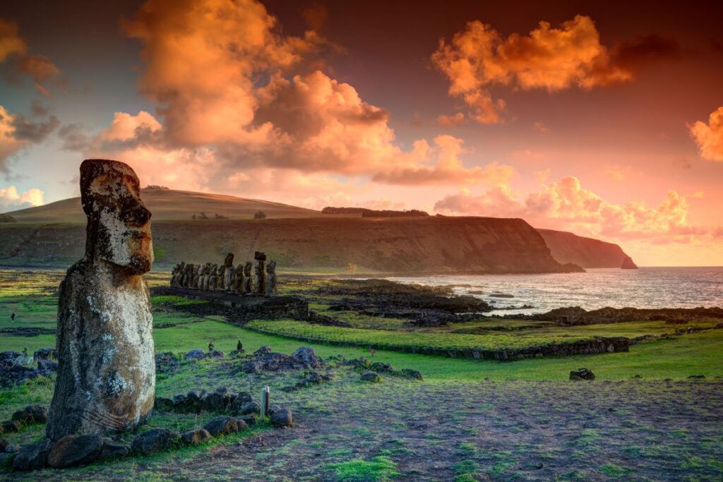
The iconic sculptures created by the indigenous people of the Rapa Nui civilization, carved in volcanic rock that in some cases exceed 80 tons in weight, were distributed at the foot of the coast, for practically the entire perimeter of the island; Each moai, which represents the ancestors (a family of the Rapa Nui ethnic group), was erected with its back to the Pacific Ocean , so that it could be admired by the people, who stood right at its feet. The name “moai” means “sculpture” in the Rapa Nui language.
At first it was thought that the inhabitants found on the island came from South America , however, recent DNA tests have shown that the inhabitants of the island were Polynesians.
A thousand years before Columbus, the Polynesians conquered the largest islands in a radius of two million square miles to the east, known as the Polynesian triangle ; from Samoa to Hawaii and New Zealand , passing through Tahiti and finally reaching Easter Island (Easter Island). Taking advantage of the ocean currents, Polynesian sailors arrived on Easter Island in canoes sometime between 400-800 AD, so it is truly surprising that the Rapa Nui ethnic group could have subsisted on the island for more than a thousand years until the first European sailors arrived.
Main types of moai: (name / zone / height).
- Moai Red Slag (Tahai) 2.5 m.
- Moai Tuturi or Tukuturi -kneeling- (Rano Raraku) 3.00 m.
- Moai Ahu Vai Uri (Tahai) 4 m.
- Moai Ko Te Riku (Tahai) 5.5 m.
- Moai Ahu Tongariki (Hotu Iti) 7 m.
- Moai Paro (Ahu Te Pito Kura) 9 m.
- Moai Rano Raraku -Terminal- (Rano Raraku) 10 m.
Due to the large dimensions of the moai, recent studies have shown that the gigantic statues, between 2.5 and 14 meters high and up to 80 tons in weight, could have been transported “standing” from the Rano Raraku quarry. by several groups of workers using strong ropes in some cases up to 18 km away to the Ahu, some stone platforms where the moai were finally located. It is very important to point out that with the platform height was gained, so that the moai acquired a greater prominence, since they could stand out and be better observed and admired by the people. Up to now, there were two hypotheses that were being considered in relation to how the moai could have been transported from the Rano Raraku quarry to their destination. The first,horizontally (with the help of wooden logs), and the other vertically (standing), predictably today the most probable theory.
Recent studies carried out in 2012 by researchers Terry Hunt and Carl Lipo ―with the unconditional support of the American company National Geographic―, for which a replica of a 3-meter-high and 5-ton moai was created using With a 3D printer specifically intended for this project, it was shown that the gigantic statues could have literally “walked” across the island with the help of strong ropes and three groups of people.
The base of the first moai, the smallest – between 2.5 and 3 meters high -, the natives carved them in a convex way. However, recent studies (verified by the prestigious local archaeologist Rapa Nui Sergio Rapu Haoa), affirm that the base of the last moai was carved in a concave way, so that the moai could walk “with relative ease” on the island until the Ahu, the ceremonial platforms where ancestors were buried, in some cases up to 20 km away from the place of origin (the quarry). It is important to note that the center of gravity of the first moai (the smallest ones) was located in the upper part of the statues, more or less at chest height, while in the case of the last moai (the terminals,those that are semi-buried in the slope of the Rano Raraku volcano quarry), the center of gravity low.
Another interesting finding discovered in 1978 by Sergio Rapu himself is that after finding 57 fragments of white coral, finally joining four of them, it was shown that they coincided and were part of the face of a moai that fortunately lay on its back, and whose face had been protected by the sand. This corroborated the term known as “Aringa Ora” in the oral tradition of the Rapa Nui language, which could be translated as “living faces” or “living faces of the ancestors”, which gave life to the Moai.
The moai that lie semi-buried have various lithic inscriptions that are still being deciphered. These inscriptions are known as Petroglyphs. According to the RAE, the Royal Spanish Academy of the language, a petroglyph is a “figure made by incision in rock, especially that made by prehistoric peoples.” Another interesting curiosity that can be deduced is that the Rapa Nui were improving and perfecting the moai, achieving greater height and better finishes through more stylized shapes; however, it is important to note that tribes also competed to build the tallest moai. As has already been suggested, the religious and political chief of each tribe (the priests), motivated their tribe to compete and build the increasingly larger and more stylized moai, but also more beautiful.
The sculptures were finished off at the top with a pukao, a kind of hat made of red volcanic stone. In addition, the eyes of the statues were decorated with plates of white coral, which turned the sculptures into living faces, which are known as Aringa Ora. The island was also nicknamed the island of San Carlos by Spanish navigator Felipe González Ahedo, who named it in honor of King Carlos III of Spain.. However, this name quickly fell into disuse; below, image of the Ahu Tongariki, the largest of the island and of all Polynesia in this genre. A sad earthquake and tsunami in 1960 toppled the 15 moai belonging to this majestic ceremonial platform measuring 220 meters in total length. The gigantic statues had fallen into the interior of the island. Years later, thanks to a Japanese crane, the 15 huge moai were able to stand.
The habitants
12 were the Rapa Nui tribes that lived on Easter Island for more than a millennium. These, which delimited their own land, always had their portion of the sea. The island’s ecosystem was very good upon arrival, full of vegetation with numerous trees. Around the year 1600 AD the island was deforested, the inhabitants were left without resources and the first wars between the tribes took place, mainly due to the lack of food ; During these wars, some of the moai were seriously damaged.
Before participating in the Man- Bird ceremony , the Hopo Manu (Competitors) celebrated a ritual meal called “Umu Tahu” and painted their bodies with “Kitea”, mineral pigments of different colors that they extracted from the island’s own cliffs.
Each competitor (Hopo Manu), had to swim back and climb the cliff of Orongo to the top with the intact manutara bird egg tied to the forehead. The first Hopo Manu to deliver him to his Arakiri (King), he was turned into Tangata manu (Bird-Man), the Religious and Political Chief of the island for a year. In this way, with a single leader, peace could finally reign on the island. The manutara, which was considered a sacred bird and its eggs a symbol of power and fertility, was one of the few species of birds that continued to migrate to Easter Island after the trees disappeared.
The island was discovered by Dutch European sailors captained by the Dutch sailor Jakob Roggeveen on an Easter Sunday , specifically April 5 , 1722 , hence its name. Around 4,000 Rapa Nui would have lived on the island until the arrival of the first Europeans in the 18th century . With the arrival of the colonizers, firearms , slavery and diseases such as smallpox and tuberculosis arrived , so that by the end of the 19th century , only 111 Rapa Nui remained on Easter Island, of which only 36 had offspring.
At present, with a population of just over 5,000 inhabitants that make their living from tourism and fishing , the Rapa Nui live in Hanga Roa, the only population center on the island; This one, which is located in the south-west area, has its own port, airport, numerous hotels and restaurants. The reality is that a large ship full of tourists arrives almost every day on Easter Island. The famous moai are the authentic tourist attraction of the island, which makes approximately 50,000 people visit it each year. Curiously, the first flight to the island of Easter occurred on 20 of January of 1951 with the aircraft called “Manutara” in honor of the bird that inhabited the island Motu Nui.
After sculpting much of the moai directly on the rock using sharp basalt and obsidian utensils , it was mined upside down; later, he was made to slide lying down the slope with the help of ropes until landing in a moat. After putting the moai on its feet, the back was finished sculpting, also outlining the arms and other finishes, including the different inscriptions. Once the moai was completed, it was transported to its destination by means of one of the three main roads that existed in the past. This procedure shows that the Rapa Nui spent much of their time in the quarry sculpting numerous moai.
Unable to take the last moai after sliding them down the slope of the quarry, the Rapa Nui carved different inscriptions on them and then semi-buried them; Do not forget that the moai represented a family of the Rapa Nui ethnic group. When a person dies, they are usually buried as a deceased person. The fact of exposing the face was a way of being able to recognize them. Given the remoteness of Easter Island with other regions, and in order to continue preserving its already weakened ecosystem – the moai are deteriorating faster and faster – it has been proposed by local authorities that the tourists themselves that they take their own garbage with them.
Some interesting data
However, thanks to local archaeologists such as Sergio Rapu, little by little we are discovering some of the enigmas that surround the gigantic statues called moai that inhabit the island, and that have given so much to talk about. What we do already know for sure is that relatively recently it has been discovered that some of these monumental sculptures were semi-buried, in some cases up to eight meters deep underground, with the particularity of having various lithic inscriptions (commonly called “Petroglyphs” (in archaeological slang), which are still being deciphered. If for experts in the field it was already very difficult to predict the approximate date of the origin of the Rapa Nui civilization that created them,This last and important discovery makes it even more difficult to clarify this great historical find, so interesting and full of mystery. Without a doubt, the moai of Easter Island are considered one of the most famous and beloved monuments in the world, being a real tourist attraction for thousands of tourists who visit the island every year.
The famous moai created by the Rapa Nui civilization ―which contribute an authentic identity to the island―, together with the last settlers of the ethnic group that still inhabit Hanga Roa, are part of the living testimony of an admirable civilization that lived isolated from the rest of the world for more than a thousand years, which knew how to get ahead on its own through the resources obtained from the island itself and the sea, becoming a great example of survival, effort and improvement.
Name
The original name of the island still generates debate: among the more traditional versions are the names Te pito o te henua (the navel of the world) and Mata ki te rangi (eyes that look at the sky), although there is no consensus on which would be the primitive denomination. Even the name that was finally adopted by the locals themselves to refer to their island, Rapa Nui (large island) was the work of other foreign sailors who, coming from Southeast Asia, christened it that way during the 19th century due to its resemblance to another island. small, the Rapa Iti (small island), located in the heart of Polynesia, more than five thousand km to the west.
Location
Located at 27 ° 09 ‘south latitude, 109 ° 26’ west longitude, approximately 3800 km west of the coast of South America , at the height of the Chilean port of Caldera (which is 873 km north of Santiago de Chile).
The locals called it Te Pito Te Henua (‘navel of the world’), given its distance from other regions and its geographical location. It has an area of 163.6 square kilometers – very similar to the dimensions of the American city of Washington D. C. -, it is located in the South Pacific Ocean, about 3750 km west of the coast of Chile. However, the land closest to Easter Island corresponds geographically to Ducie Island, belonging to the British territory of the Pitcarn Islands, which are located about 2075 km to the west.
Limits
Located in Polynesia , in the middle of the Pacific Ocean . It is the largest of the islands of insular Chile.
Demography
It has an area of 163.6 km² and has a population of 5,761 inhabitants.
Legends
There are various theories about the past of Easter Island, which contributes to the mystery that surrounds it. For the settlers, its history is explained through oral tradition and mythology . She tells that the ariki (king) Hotu Matu’a, along with his sister the ariki Vi’eAva Rei Púa and 100 other men, left their homeland Hiva in the 4th century AD guided by instructions from the royal councilor Haumaka. Thus, aboard two boats they arrived at Te Pito or te Henua, the spiritual center of the Polynesian worldview.
According to the legend, the ariki Hotu Matu’a established the social and religious organization of the community, determining the norms of kinship and descent and the construction of houses and monuments.
The moai are its main symbols and stand around the 250 ceremonial altars or Ahu. Together with the petroglyphs engraved on the volcanic stones, these beautiful megalithic sculptures represent the richness of the ancient Rapa Nui culture. In them the images of their ancestors who happened to witness all the ceremonies of the town were reflected. In the 16th and 17th centuries, a social crisis began that generated new tribal wars and the decline of the Moai culture. As there are almost no written testimonies, part of this history has passed into enigmatic oblivion. For their part, anthropological and archaeological investigations confirmed that groups from Southeast Asia had migrated to Melanesia and Polynesia occupying most of the islands of Oceania up to the limits of this insular territory: Hawaii , New Zealand and Easter Island. The crossings would have been made in double canoes of 30 meters in length and more than 8 meters in height and the settlement of Rapa Nui would have been in the year 300 AD
It was not until 1772, when the Dutchman Jacob Roggeween arrived in the islands on Easter Day, that contact between the inhabitants of Rapa Nui began with the rest of the world and it is from this year that there are written records of your culture.
Some fragments of the story told by the old Pua Ara Hoa and collected by Simeon Riroroko in 1910. In 1959 this manuscript was published by the German Thomas Barthel, who translated it thanks to the contributions of the islanders Arturo Teao, Esteban Atan and Aaron Pakarati: